Slides – Urban Patterns Formation: Bottom-up Patterns | Emergent Urban Strategies
Exercise 4
Download any topography data (any GeoTIFF relief -Digital Elevation data from https://geodata4edu.ethz.ch/portal.jsp or earthexplorer.)
Convert to JPEG, import the file to Rhino, make a surface from an image. Use Grasshopper definition, e.g. here.
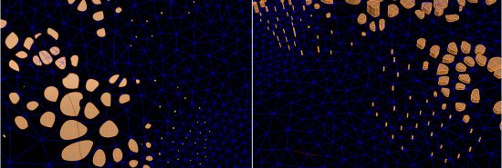
Tessellate the surface by means of appropriate method (e.g. Voronoi or others according to the morphological characteristics of the land area) and scale the subdivided parts according to the prefered attractor points or prefered typology of urban formations. (You can use several attractors on a curve). Try several possibilities of scaling / transformations / formations.
Populate the tessellated surface with buildings in relevant form (e.g. use and scale the shape of plots) according to certain rule-set (e.g. distance restrictions from attractor points, connectivity with the road network, etc.)
Simulate the growth of the city and analyse it by means of previously introduced analytical methods.
Study the video tutorials. Bring your own ideas to the system, change certain characteristics, try to use any other modelling methodologies or techniques/parameters. Prepare/send us your questions.
Video Tutorials:
Scaling according to the first attractor point
Network mapping and Path detection
Other types of tessellation:
Templates for the documentation (you can use more pages again):
Word: template
InDesign: template
Deadline – extended 07.11. 2016


