FS2018 | Information Architecture and Responsive Cities
To demonstrate the potential of Responsive Cities, this course will define the concept of Citizen Design Science, a combination of Citizen Design, Citizen Science and Design Science. Experts, citizens and scientists participate in Citizen Design Science. This approach is still in an early stage of development, but with the Responsive Cities Massive Open Online Course, you will be ahead in exploring and defining its possibilities.
‘Responsive cities’ is the fourth edition of the ‘Future Cities’ series on urban MOOCs. The ‘Future Cities’ series is the first and complete series of urban courses dealing with the design, management and transformation of cities for their sustainable and resilient future. With every edition, the series becomes more interactive. It increasingly empowers citizens around the world to become part of the development of their own cities, especially in those places where this knowledge is needed most. Therefore, the course is inclusive for every individual interested in the planning, construction, redevelopment and management of future cities. The course is open to anyone regardless of background, skills, knowledge, or age.
Swiss MOOC on Responsive Cities
FS2018 | Digital Urban Simulation
A solid knowledge of computational methods is an increasingly important key competence for future architects or urban planners.
In this course students analyze architectural and urban design using current computational methods. Based on these analyses the effects of planning can be simulated and understood. An important focus of this course is the interpretation of the analysis and simulation results and the application of these corresponding methods in early planning phases.
The students learn how the design and planning of cities can be evidence based by using scientific methods. The teaching unit conveys knowledge in state-of-the-art and emerging spatial analysis and simulation methods and equip students with skills in modern software systems. The course consists of lectures, associated exercises, workshops as well as of one integral project work.
In a series of theory lectures we explore how designing and planning of cities could become more evidence based by using scientific methods. Various exercises will provide training for your skills in working with state-of-the-art yet office-proven design tools (Rhino/Grasshopper and add-ons). In an integral project work, you will deepen your knowledge in spatial analysis and simulation methods such as Space Syntax using ConfigUrbanist and Decoding Spaces components packages and environmental analysis with the add-ons LadyBug and HoneyBee. In addition, you will acquire skills for using analysis methods for generative design processes. Therefore we introduce you into the parametric design software Grasshopper for Rhino 3D.
Based on the methods introduced during the semester, you will learn and understand different effects of planning and design interventions on urban life. At the end of the course you will be able to interpret analysis and simulation results, and to apply corresponding computational methods to your own planning projects.
Lecture, HIT F22 – Value Lab
Exercises, HIT H12
Course flyer
Teaching material is provided on moodle.
Supervision:
Dr. Estefania Tapias
Dr. Peter Buš
FS2018 | Creative Data Mining
The Creative Data Mining course aims to provide aspirants a hands-on experience on machine learning (ML) tools and techniques for data processing and data analysis. Since future technologies increasingly rely upon machine learning, urban systems and architecture shall adopt it and the aspirant should learn creative ways to apply ML to better understand urban systems. The course covers a wider range ML techniques including supervised and unsupervised learning methods for data analysis and pattern recognition that help to better understand urban system for improving urban life.
All methods taught in the course will be applied to a common project to evaluate various dynamics of the urban environment. Students will work with time-series and geo-referenced data including temperature, relative humidity, illuminance, noise, people density, and dust particulate matter. Subjective impression survey data will also be integrated into the student projects to further explore influencing factors of the urban environment on our perceptual experiences. A selected neighborhood in the city of Zurich will be used as the case study and each student will present the findings of their research question in a final project.
Additionally, there are two of non-architectural skills the participants can develop during this course. First is an introduction to programming where at a minimum they can successfully use code-snippets to customize the computational tools presented in the course. Second, how clustering methods like PCA or K-Means could be applied in an architectural context.
Where: HIT H 31.4 (Video wall)
When: Mondays 10:00 – 12:00
2 ECTS
Supervision:
Course Flyer
HS2017 | Digital Urban Simulation
A solid knowledge of computational methods is an increasingly important key competence for future architects or urban planners.
In this course students analyze architectural and urban design using current computational methods. Based on these analyses the effects of planning can be simulated and understood. An important focus of this course is the interpretation of the analysis and simulation results and the application of these corresponding methods in early planning phases.
The students learn how the design and planning of cities can be evidence based by using scientific methods. The teaching unit conveys knowledge in state-of-the-art and emerging spatial analysis and simulation methods and equip students with skills in modern software systems. The course consists of lectures, associated exercises, workshops as well as of one integral project work.
In a series of theory lectures we explore how designing and planning of cities could become more evidence based by using scientific methods. Various exercises will provide training for your skills in working with state-of-the-art yet office-proven design tools (Rhino/Grasshopper and add-ons). In an integral project work, you will deepen your knowledge in spatial analysis and simulation methods such as Space Syntax using ConfigUrbanist and Decoding Spaces components packages and environmental analysis with the add-ons LadyBug and HoneyBee. In addition, you will acquire skills for using analysis methods for generative design processes. Therefore we introduce you into the parametric design software Grasshopper for Rhino 3D.
Based on the methods introduced during the semester, you will learn and understand different effects of planning and design interventions on urban life. At the end of the course you will be able to interpret analysis and simulation results, and to apply corresponding computational methods to your own planning projects.
Lecture, HIT F22 – Value Lab
Exercises, HIT H12
Course flyer
Teaching material is provided on moodle.
Supervision:
Dr. Estefania Tapias
Dr. Peter Buš
HS2017 | Information Architecture and Responsive Cities
To demonstrate the potential of Responsive Cities, this course will define the concept of Citizen Design Science, a combination of Citizen Design, Citizen Science and Design Science. Experts, citizens and scientists participate in Citizen Design Science. This approach is still in an early stage of development, but with the Responsive Cities Massive Open Online Course, you will be ahead in exploring and defining its possibilities.
‘Responsive cities’ is the fourth edition of the ‘Future Cities’ series on urban MOOCs. The ‘Future Cities’ series is the first and complete series of urban courses dealing with the design, management and transformation of cities for their sustainable and resilient future. With every edition, the series becomes more interactive. It increasingly empowers citizens around the world to become part of the development of their own cities, especially in those places where this knowledge is needed most. Therefore, the course is inclusive for every individual interested in the planning, construction, redevelopment and management of future cities. The course is open to anyone regardless of background, skills, knowledge, or age.
Swiss MOOC on Responsive Cities
HS2017 | Creative Data Mining
The Creative Data Mining course aims to provide aspirants a hands-on experience on machine learning (ML) tools and techniques for data processing and data analysis. Since future technologies increasingly rely upon machine learning, urban systems and architecture shall adopt it and the aspirant should learn creative ways to apply ML to better understand urban systems. The course covers a wider range ML techniques including supervised and unsupervised learning methods for data analysis and pattern recognition that help to better understand urban system for improving urban life.
All methods taught in the course will be applied to a common project to evaluate various dynamics of the urban environment. Students will work with time-series and geo-referenced data including temperature, relative humidity, illuminance, noise, people density, and dust particulate matter. Subjective impression survey data will also be integrated into the student projects to further explore influencing factors of the urban environment on our perceptual experiences. A selected neighborhood in the city of Zurich will be used as the case study and each student will present the findings of their research question in a final project.
Additionally, there are two of non-architectural skills the participants can develop during this course. First is an introduction to programming where at a minimum they can successfully use code-snippets to customize the computational tools presented in the course. Second, how clustering methods like PCA or K-Means could be applied in an architectural context.
Where: HIT H 31.4 (Video wall)
When: Mondays 10:00 – 12:00
2 ECTS
Supervision:
Course Flyer
URBAN AUTOPOIESIS
Towards Adaptive Future Cities
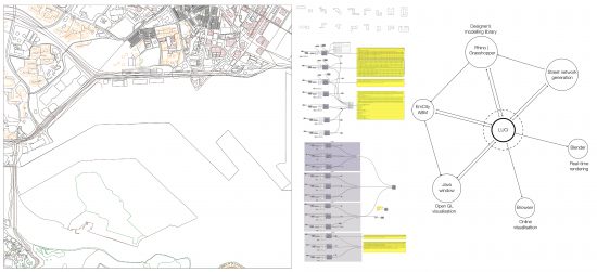
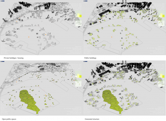
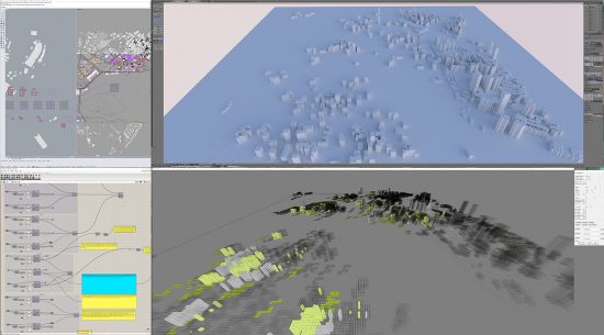
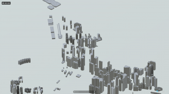
A city, defined as a unity of inhabitants with their environment and showing self-creating and self-maintaining properties, can be considered as an autopoietic system if we take into account its bottom-up processes with unpredictable behaviour of its components. Such a property can lead to self-creation of urban patterns. These processes are studied in well-known vernacular architectures and informal settlements around the world and they are able to adapt according to various conditions and forces. The main research objective is to establish a computational design-modelling framework for modelling autopoietic intricate characteristics of a city based on an adaptability, self maintenance and self-generation of urban patterns with adequate visual representation. The research introduces a modelling methodology that allows to combine planning tasks with inhabitantsí interaction and data sources by using an interchange framework LUCI to model more complex urban dynamics. The research yields preliminary results tested in a simulation model of a redevelopment of Tanjong Pagar Waterfront, the container terminal in the city of Singapore being transformed into a new future centre as a conducted case study.
Keywords: Cognitive Design Computing, Interactive Urban Synthesis, Urban Computational Models, Future-Oriented Computational Design, Urban Metabolism; Urban Autopoiesis; Computational Interchange; Emergent Urban Strategies; Adaptive City.
Publications:
Buš, P., Treyer, L. & Schmitt, G., (2017). Urban Autopoiesis: Towards Adaptive Future Cities. CAADRIA 2017 Protocols, Flows and Glitches, Xi’an JiaotongLiverpool University, Suzhou, China.
eth research collection
full paper:
CumInCAD repository
Contact:
PETER BUŠ | bus@arch.ethz.ch | +41 76 278 6087
LUKAS TREYER | treyer@arch.ethz.ch | +41 44 633 27 80
FLOATING CITIES
Addressing high demand for new public urban spaces by exploring reclaimed water areas
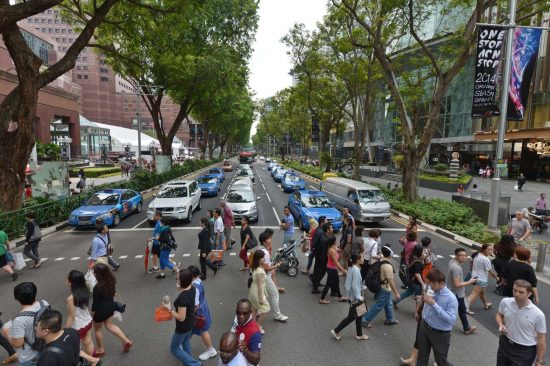
Urban water spaces, lakes and rivers have an impact on the image of the city and have played a key role in the social and economic development of cities throughout the centuries. As economic, social and cultural values of an urban land is immensely increasing, a high demand for new public urban spaces leads to reclaiming of water areas within the cities. Such urban and architectural interventions within water environments attract citizens and visitors to occupy these places and interact with them, bringing new cultural and social values which enhance a particular urban identity. As different social groups and activities, as well as considerations addressing climate change and increasing sustainability and resilience place different demands on design and use, the redevelopment of urban waterfronts provides an ideal testbed for new concepts of citizen engagement and adaptive and responsive urban developments.
Problem statement
At the same time our cities, neighbourhoods, buildings, and urban spaces suffer from the problem of standardized production, repetition, uniformity, monotony and similitude. There is a gap between industrially fabricated elements of small scale prototypes (such as cars) to extra-large architectures, urban environments, and cities in general (Verebes 2015). The ubiquitous standards, common production in a building industry and fixed permanent solutions that are no longer actual can lead to anonymous and estranged life and societies in cities. However, a city often changes and is activated from bottom-up and this characteristic of its fluidity and state of continuous flux strongly seeks for a feature of its adaptability. More specifically, it appeals for such systems that can adapt to local specificities with the impact on their spatial and geometrical qualities and with a consideration to urban density, interstitial space, connectivity, diversity and in respect to differentiated local climate zones (Weinstock 2013).
Architectural and urban planning is nowadays a highly specialised process, which does not actively engage the users of these spaces in the design process and in consequence to some extent neglects their needs, preferences, and also does not take advantage of their local and living knowledge of a place, which could benefit the design of more diverse, adapted and adaptive environments. Although participatory processes exist and have occasionally been successfully implemented, generally applicable frameworks or process models are scarce or non-existent as well as the tools to support these.
Research Goal
To address these challenges of contemporary cities and to support citizen engagement in the design process and the adaptation of urban space according to their needs (Seraj 2015), the goal of the research project was to develop a customised floating spatial system, which is modified and adapted on-site in a full scale directly by citizens as end users. The resulting system will be ready to explore, to react appropriately on citizens’ inputs, to create, to share and to assemble physically and in an interactive way on-site and fully bottom-up in order to empower and activate the local community, enhance community life and provide opportunities for participation and the contribution of community values (Bullivant 2017) with an impact to liveable conditions of the given environment. In so doing, the research proposed a prototype of a floating proto-architectural system, consisting of a set of simple pre-defined modules which can be assembled, re-assembled and assembled again in different configurations by the end users (citizens) on-site, leading to a diverse number of more complex architectural and spatial variants. Water, as a key environmental and architectural feature of a given space, can serve as a medium for adaptability, flexibility and interaction with the system.
Keywords: adaptive cities, floating cities, bottom-up urbanism, on-site participation, user-driven customised cities, urban floating proto-assemblies, responsive cities, citizen participatory design
Contact:
PETER BUŠ | bus@arch.ethz.ch | +41 76 278 6087
AYÇA TARTAR | tartar@arch.ethz.ch | +41 44 633 70 47
Mei-Chih Chang | chang@arch.ethz.ch |
Katja Knecht (FCL Singapore)
Xu Ming (FCL Singapore)
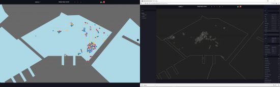
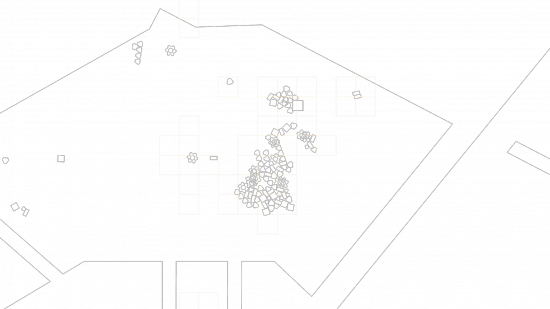
CITIZEN DESIGN SCIENCE
A combination of Citizen Science and Design Science employing bottom up flow of data and information to improve the planning and functioning of a city.
The last decades in urban design research are characterised by a focus on technological aspects of cities which is commonly known as the smart city strategy. The concerns and interests of citizens are coming to the forefront nowadays with the awareness that a liveable city does not only consist of good infrastructure and sustainable energy supply but also citizen input and feedback. In this paper, we present Citizen Design Science as a new strategy for cities to integrate citizens’ ideas and wishes in the urban planning process. The approach is to combine the opportunity of crowdsourcing opinions and thoughts by citizens through modern information and communication technology (ICT) with active design tools. The active design feedback from a city’s inhabitants is identified as a yet missing but essential way towards a responsive city. We therefore proposed a system to merge Citizen Science and Citizen Design, which requires a structured evaluation process to integrate Design Science methods for urban design.
We show examples of existing approaches of Citizen Design Science and present the Quick Urban Analysis Kit (qua-kit) as an application of this methodology. The toolkit allows users to move geometries in given environments and provides the opportunity for non-experts to express their ideas for their neighbourhood or city.
If there is no Citizen Science, the active designing with people will stay on a low level. Even for design issues on a neighbourhood scale, it is nowadays necessary to involve more than thousands of people since many people live in one neighbourhood of a high-density urban area.
CDS without Citizen Design, may be an option for current cities to become more liveable. However, it does not enable opportunities to get creative ideas for urban design. The allure of Citizen Design is also the gamification aspect. Not only is it a “no right or no wrong” process, but people can also express their ideas in an unanticipated way which could mean a higher motivation to participate.
Design Science methods are indispensable for CDS. It is simply not feasible for a designer to analyse thousands of design proposals and find commonalities between all ideas. In the same way, technologies are used to provide tools for Citizen Science, they must be employed to evaluate the designs.
Contact:
Hangxin Lu | lu@arch.ethz.ch | +41 (0) 44 633 72 14
Johannes Mueler (FCL Singapore)
MACHINE LEARNING AND URBAN IDENTITY
Unsupervised machine learning approach to exploring important features of urban identity from the quality of public spaces.
Public spaces play an important role in the processes of formation, generation and change of urban identity. Under present day conditions, the identities of cities are rapidly deteriorating and vanishing. Therefore, the importance of urban design, which is a means of designing urban spaces and their physical and social aspects, is ever growing. This research focused on developing a novel methodology by using the unsupervised machine learning approach to explore important features of the urban identity from the quantifying quality of public space. The methodologies of quantifying quality of public space are integrated K. Lynch’s work with space syntax and POI. Western and Eastern cities (Zürich and Singapore..etc) were the case studies to compare and explore the urban identity. This strategy helped to improve planning, design process and generation of new urban patterns with more appropriate features and qualities.
Contact:
Mei-Chih Chang | chang@arch.ethz.ch |