2013-APR-08
What you need to proceed:
On the server in “INPUT->TripodPotion” you will find a folder “ZH_curveGuides”.
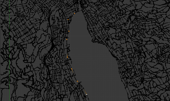
The movie “zurich_view_curve_guides_720p.mov” (schmitt-server.ethz.ch/schmitt-stud/FS2013_ComplexCity/INPUT/TripodMotion/ZH_curveGuides/ zurich_view_curve_guides_720p.mov) will give you an impression on transit routes in Zurich visualized with a path animation. For those of you, who were in the last class (week 4): With a few more tracks we managed to fit the 3D model much better to the footage. Also, we replaced the Open-Street-Map Road Network with a GIS import from geodata.ethz.ch which led to more accuracy as well. In the Zurich-View-Curve-Guide-Blend-File you will find Buildings and main streets, all adjusted to the topography. The scripts for importing the ESRI-Shapefiles from geodata.ethz.ch are included in the file “afp://schmitt-server.ethz.ch/schmitt-stud/FS2013_ComplexCity/INPUT/TripodMotion/zurich_GIS_meshes.blend”. It uses a Python-Script that provides access to shapefiles. There you will find also a script called “find_streets.py” that completes a rough selection of vertices in a streetnetwork, as shown below.
Rough selection of vertices in a street network.
The “mask.py” script lets you delete anything outside a plane called “Mask”. (Useful to make a selection in this Blend-File containing the open-street-map export of all of Switzerland)
“buildings2topography.py” will move all flat geometry (building footprints) to a 3D-surface (topography).
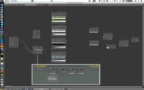
Additionally, here you have a cycles material setup that visualizes also the direction of the animated flow:
path_animation_traffic.blend Be aware that this file was created with a pre-release version of 2.67 and causes your 2.66 version to crash if you want to open it. Screenshot of the node setup:
For Friday 12th April please choose among one of the topics below or come up with your own:
- Traffic (private/public or cargo/pedestrian or your own category)
- Geometric Analysis (e.g. Visibility, Space Syntax, Liveable Streets)
- Points of interest and their hinterland (sports/medicine/culture/subculture/shopping/money)
- Housing: Segregation / Gentrification
- Education / Innovation
- Identification (with the city), Pride
- Flows: Energy, Food
- Kids / Old people / marginalized people
- Crime
- History / Future Projects (MyCity)
- “your own topic”
Form groups of 2. Find data. In case you are not successful contact us. We might help out.
Create skteches, discuss them. Create 1 pan shot and 1 or more close ups (and/or a time lapse). Make sure your footage is clear and steady enough to be tracked at a later stage. Cut the video; target length: 30-50sec.
Motion Tracking in the raw footage. If dealing with a tripod footage fit your 3D model by hand. Don’t use the model for masking. It’s too hard to make a tripod footage fit precise enough when you deal with an areal shot of a city. Use the masking tools instead (make sure you know what a shape-key is). If needed, create masks with Gimp/Photoshop and place them in front of your camera (on a UV-mapped plane).


